The Archaeological Discoveries At Whirlow Hall Farm
During two Heritage Lottery funded archaeological projects many amazing discoveries have been made at Whirlow Hall Farm. These discoveries provide evidence of human’s activities here on the fields surrounding Whirlow from the first hunter-gatherers who followed the herds of animals colonising the area after the last Ice Age right up to the farm we can visit today.
The first project was managed by Whirlow Hall Farm Trust and Archaeological Research Services Ltd. (ARS Ltd.) and the second project was managed by The Time Travellers, a local archaeological group, supported by professional archaeologists, ARS Ltd and involved many volunteers from the local community. The two projects covered desk based research, building survey , fieldwalking, geophysical survey and excavations. In addition the projects trained volunteers in archaeological skills and provided funds to spend on bringing the heritage uncovered to the attention of the community, through guided tours, talks, videos, and a well attended heritage day.
The first project was managed by Whirlow Hall Farm Trust and Archaeological Research Services Ltd. (ARS Ltd.) and the second project was managed by The Time Travellers, a local archaeological group, supported by professional archaeologists, ARS Ltd and involved many volunteers from the local community. The two projects covered desk based research, building survey , fieldwalking, geophysical survey and excavations. In addition the projects trained volunteers in archaeological skills and provided funds to spend on bringing the heritage uncovered to the attention of the community, through guided tours, talks, videos, and a well attended heritage day.
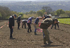
Fieldwalking is a simple and rewarding archaeological technique. Volunteers were directed to walk across newly ploughed fields in a regularly spaced line to ensure every square metre was searched for artefacts. Finds were marked with canes and their location recorded prior to bagging, cleaning and further analysis. It was largely through this activity that evidence of our most ancient past was found in the form of flint and chert tools left on the fields where our ancestors hunted or prepared their catch.
Experts can classify flint artefacts through knowledge of flint knapping techniques and the style of tools made in the different time periods.
Experts can classify flint artefacts through knowledge of flint knapping techniques and the style of tools made in the different time periods.
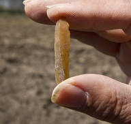
Included amongst our fieldwalking finds were flint tools in the form of blades and scrapers left by Mesolithic hunter-gatherers (9,700-4000BC) from just after the last Ice Age, and from the Neolithic (4000–2400 BC) period, by which time our ancestors were starting to settle and farm the land. We also found scrapers and an arrow head typical of the Bronze age (2400-700 BC). Flint continued alongside bronze as a raw material for tool production for centuries.
The location of Whirlow sitting on the edge of the steep sided valley leading down to the Limb Brook would have been an ideal hunting ground for red deer, wild pig, fowl and fish. Later the south-east facing slopes would provide a fertile setting for farming that has lasted here at Whirlow for thousands of years.
The location of Whirlow sitting on the edge of the steep sided valley leading down to the Limb Brook would have been an ideal hunting ground for red deer, wild pig, fowl and fish. Later the south-east facing slopes would provide a fertile setting for farming that has lasted here at Whirlow for thousands of years.
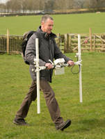
Geophysical surveying of the fields around Whirlow was employed to identify buried archaeological features. This technique uses equipment which measures the strength of the ground’s magnetic field and records this in great detail as one traverses a field holding the equipment at a set height and in a well-defined pattern to ensure no area is missed. Differences in the strength of the magnetic field are recorded and then plotted by a computer programme. The patterns that emerge provide visual evidence of what lies hidden beneath the grass and soil.
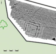
The geophysical surveys of the fields surrounding Whirlow have been very productive. In the 2011 project the outline of what has since proven to be a large rectangular Iron Age-Roman period ditched enclosure and the 2016/17 surveys have identified the foundations of a Roman observation/signal tower, bringing new light on Sheffield’s little known Roman past. Further surveys have identified many other exciting and tantalizing buried features which are just crying out for further archaeological investigation.
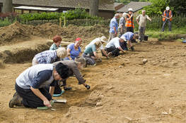
The discoveries made by the geophysical surveys informed our professional archaeologists where best to excavate.
Firstly, an area encompassing the ditch of the enclosure and what looked like an entrance causeway over the ditch was carefully excavated by our many volunteers, closely supervised by the team of professional archaeologists from ARS Ltd. Down on our hands and knees layers were scraped off and any find or feature carefully recorded, position registered, stratified, bagged and cleaned for further investigation and classification.
What emerged from its hiding place beneath the field was a very large rock-cut, ditched enclosure. This enclosed an area 71 metres wide and likely to have been at least as long but, unfortunately, truncated after 43 metres by the building of bungalows in the adjoining field. This is a very large settlement for its type when compared with other such sites previously discovered.
Not only did the expected ditch appear but so too did the entrance causeway. Across the causeway and within the enclosure we discovered a metalled surface of stone from amongst which emerged fragments of Roman period pottery.
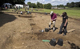
During the 2016 excavation we discovered that a construction slot had been dug across the entrance causeway, believed to have carried a timber beam off which a wooden entrance gateway would have been built. Just inside the gateway a clearly identifiable post hole was discovered, likely to be associated with the entrance gateway construction. Other pits were discovered nearby and one which lay below the Roman period surface gave up fragments of rare late Iron Age or early Romano-British pottery.
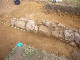
Furthermore, our towelling revealed the base of a stone founded building and within that building we found further evidence of Roman occupation: pottery, iron nails, and a shard of ancient blown glass.
Pottery is extremely important in helping to date associated archaeological features, as it has very distinct material, manufacturing process and style. All are elements which the expert can use to identify, locate the source and to date.
At least seven different styles of Roman Period pottery were found including Derbyshire ware, Grey ware and Samian ware. The first two have been sourced quite locally while Samian ware is known to have originated from Gaul.
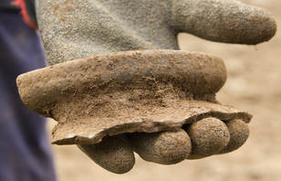
Much of the pottery was actually found within the construction slot across the causeway. This suggests that the site was slighted when abandoned, the construction beam removed from the slot and broken pottery discarded along with other backfill into the slot where it was to lie for 17 centuries or more until being discovered by one of our excited volunteers.
Further trenches were excavated across other features revealing evidence of some form of metal working. Finds of fragments of metal alloy fragments were subjected to analysis by Roger Doonan and his team at Sheffield University. Their analysis suggest both iron smithing and working of objects made of pewter, a tin and lead alloy, occurred on the sited to the immediate East of it. Much of this evidence came from deposits radiocarbon dated to the Roman occupation.
Further trenches were excavated across other features revealing evidence of some form of metal working. Finds of fragments of metal alloy fragments were subjected to analysis by Roger Doonan and his team at Sheffield University. Their analysis suggest both iron smithing and working of objects made of pewter, a tin and lead alloy, occurred on the sited to the immediate East of it. Much of this evidence came from deposits radiocarbon dated to the Roman occupation.
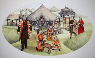
Apart from the nature and style of pottery informing the dating of our site, finds of seeds and particularly hazel charcoal were found and were able to be radiocarbon dated. The results lead us to believe that this enclosure was built and inhabited in the Iron Age from around 350-121 BC
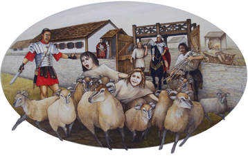
Then in the late 1st/early 2nd century AD came life under the Romans who re-modeled the enclosure in their own style. Possibly, the land was given to a Roman veteran to own, farm and provide produce for the Roman military.
Finds from the construction slot which can be assumed to be indicative of the time the site was abandoned were radiocarbon dated to the late 3rd/early4th century AD. This suggests Iron Age occupation of this site for around three hundred years followed by Roman occupation for possibly a further two hundred years!
Finds from the construction slot which can be assumed to be indicative of the time the site was abandoned were radiocarbon dated to the late 3rd/early4th century AD. This suggests Iron Age occupation of this site for around three hundred years followed by Roman occupation for possibly a further two hundred years!
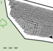
Another exciting discovery by the geophysical survey and confirmed by a limited excavation trench has been interpreted as the base of a Roman observation/signal station.
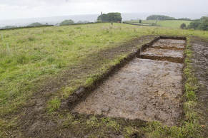
Located at the highest point with extensive views and a direct line of sight to Templeborough, a known Roman Fort.
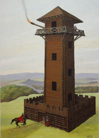
This provides a new concept of the Roman history of this area: “Was this observation tower one of a series along a previously undefined early Northern Roman frontier prior to the Roman advance into the tribal lands of the Brigantes and then beyond?”
After the Roman’s abandoned Britain in AD 410 we enter what is called the “Dark Ages”. Although, anything but dark, it is named so due to the lack of written historical documents for this period. The only evidence we have of this period on this site is left in the place names: "Whirlow", the word “low” is an Anglow-Saxon suffix often referring to a low hill, mound or barrow. Other well known local examples are Arbor Low and Minninglow. Also, the word “Limb” of the Limb Valley means “limit” in Anglo-Saxon and we know that the Limb Valley, formed part of the border between Northumbria and Mercia throughout much go their existence. So it is very plausible that this valley was an ancient tribal boundary going far back into prehistory and may well have defined an early northern Roman frontier along the tribal boundary between the Brigantes and the Corieltauvi.
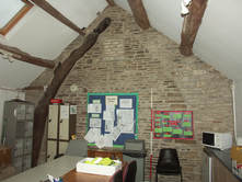
As we fast forward to more modern times the project’s desk top research and buildings survey start to bridge Whirlow’s history from the early Medieval period through to today.
Desk top research, looking through archived documents, maps, aerial photos and other journals revealed that medieval sources indicated that there was an estate of some importance in the 12th century. “Horlowe” (i.e. Whirlow) was later noted in a grant in 1296. Also a timber-framed hall was mentioned in a deed from 1303 when Robert de Ekilsale (ie Ecclesall) gave lands to John of Horloe (ie Whirlow). The remains of this hall or associated barns is probably in evidence as the remnants of wooden cruck beams that can still be seen built into walls of the current office and café buildings.
This John of Horloe may well have been John Bright of the Bright family whose family owned Whirlow for hundreds of years, remaining in their possession until 1720, when it was reputedly lost due to the “high living” of one Henry Bright.
The Brights initially created their wealth through the wool trade and then by metalworking. They were known to have been making arrowheads at Whirlow from as early as 1501. The woods produced charcoal and white coal which were utilised for lead smelting in the area on the estate known as “Bole Hill”. Whirlow wheel dating from the early 1500’s was used amongst other things for grinding corn.
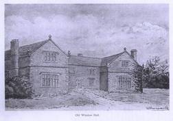
A grand “Old Whirlow Hall” was built of stone during the Elizabethan period (1558-1603 AD) and its wealth suggests this as the most prosperous period in Whirlow’s history. One room was noted as being 9 yards wide and held glass windows with 470 panes!
During the late 17th – early 18th century Low Cottage and more of the farm buildings that we see today were built. Recently a door dated 1652 has been found. By the end of the 17th century other cottages had sprung up around two ponds known as Whirlow Green and from here various cottage industries bleached and dyed cloth and engaged in metal working. These ponds are now buried having been located near the car park and the water course has since been culverted.
Interestingly, after leaving the Bright family and as early as 1725 Whirlow Farm was sold to Thomas Hollis who subsequently donated it to a charitable trust “The Hollis Hospital Trust”. This trust raised funds from the estate by letting it out to tenant farmers. It is truly amazing that this estate has been used for charitable purposes ever since!
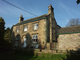
The “Old Hall” fell into disrepair through poor stewardship by the tenants and in 1842 the Hollis Trust built a new hall that still stands today. The first tenants were the newly married couple of Mary Dungworth and William Furness. In 1851 we know that William Furness was not only farming the land but was producing scythes, shares and other blades at Whirlow and they were finished off on a grinding wheel at Whirlow Mill.
The wheel at Whirlow Mill continued in use and a turbine was installed to power the mill until as late as 1901, while the farm continued to be tenanted by the Furness family until 1937.
After the first World War the remaining estate was purchased by Sheffield City Council and tenanted by Dennis Merryweather until the 1970’s. In 1979 an educational trust was created, Whirlow Hall Farm Trust, which continues today to provide educational opportunities for thousands of school children and the local community to experience and learn about farming as a way of life.
Over the course of these two amazing projects and with lots of hard work by both our professional archaeologists, led by Dr. Clive Waddington, a host of community volunteers, Sheffield Photographic Society, U3A, Sheffield University, and many members of The Time Travellers we have made a good start in uncovering evidence of the continuity of man’s activities here on the lands of Whirlow Hall Farm from not long after the last Ice Age right up until today. Many thanks go to all involved, the generosity of the Heritage Lottery Fund and the support of Whirlow Hall Farm Trust, Archaeological Research Services and the University of Sheffield.
For a more dea


